Since the colonial period, maps of Africa served two main purposes: to identify the demarcation of European colonies and to falsely show the continent’s size compared to other global land masses.
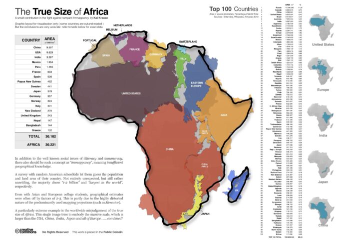
According to Daily Express reporter Grace Piercy, a graphic by Design 109 “shows Africa is larger than the land masses of the U.S., China, India, Mexico, Peru, France, Spain, Papua New Guinea, Sweden, Japan, Germany, Norway, Italy, New Zealand, the UK, Nepal, Bangladesh and Greece put together.”

In her October 15 article published on express.co.uk titled: “Incredible map shows ‘true’ size of Africa—China, India and America all fit inside,” Piercy writes that though “the continent of Africa covers 20 percent of the planet’s land area and six percent of its total surface area … it is not accurately shown on the standard map, made with the Mercator projection. It makes countries along the equator appear smaller and countries closer to the poles larger.”
Mercator projection was presented by Gerardus Mercator in 1569. Why this false representation of Africa on modern-day maps continues is anyone’s guess. There is a fight against rampant “immappancy,” or a lack of geographical knowledge.
This term was coined by Kai Krause who created the term to highlight the misrepresentation of the world’s geography. This distortion can potentially skew peoples’ understanding of the world and their places as members of the global community.
According to the website of the Illinois Center for Global Studies, according to Krause, “A survey with random American school children let them guess the population and land area of their country. Not entirely unexpected, but still rather unsettling, the majority chose ‘1-2 billion’ and ‘largest in the world,’ respectively.
Even with Asian and European college students, geographical estimates were often off by factors of 2-3. This is partly due to the highly distorted nature of the predominantly used mapping projections (such as Mercator).” A particularly extreme example is the worldwide misjudgment of the true size of Africa.
To help explain the importance of an accurate knowledge of geography and to introduce the relevancy and importance of the study of cartography (the art and science of graphically representing a geographical area), brothers and sisters coming into the Nation of Islam are required to memorize and study Student Enrollment and Actual Facts.
Contained in The Supreme Wisdom Lessons which includes in part information on the measurement and area of the land and bodies of water on the planet earth.
In Muhammad Speaks newspaper, published by the Honorable Elijah Muhammad, Eternal Leader of the Nation of Islam, a form of cartography was used in an illustration by Brother Eugene Majied.
The caption on one of Brother Eugene’s illustrations read, “The serpent deceived the whole world,” and depicts how U.S. imperialist power had besieged and conquered the entire planet.
Viewing a map of Africa precipitating from “the scramble for Africa—the period where European nations colonized the continent—and beginning with the year-long 1884-85 Berlin Conference, you discover “color-coded” maps of the continent to show what each European power laid claim to. The key on these maps is found in the bottom left or right-hand corner.
“The divisions were arbitrarily decided by the colonizing countries. They were not based on existing tribal or geographical boundaries. Some of the new boundaries split tribes in half. Others made huge territories that were difficult to control.
This led to conflicts in the twentieth century, when the colonized countries became independent,” explained a study titled “The Scramble for Africa” by St Johns College: University of Cambridge.
Another study: “Mapping Africa: Problems of Regional Definition and Colonial/National Boundaries,” published by the University of Chicago, stated that colonial maps imposed serious disadvantages upon Africa, “although perhaps less due to the specific boundaries they established than to the way they imposed outwardly oriented development patterns upon the continent.”
“‘Balkanization’ into numerous territories of varying sizes rather than a few big units is only a problem if one assumes that ‘bigger is better,’ which is not demonstrated by the relative success of various postcolonial states, e.g.,
Some of the very large ones such as Sudan and the Republic of Congo have experienced the most severe problems (even though the Congo has significant natural and mineral reserves),” the study noted.
“More significant, perhaps, was the competitive outward orientation of transport networks that did not link African territories to one another but rather tied each to a port within its own colonial domain and ultimately to trade with its European metropole.”
Follow @JehronMuhammad on X


