


FCNNEWSSOURCE
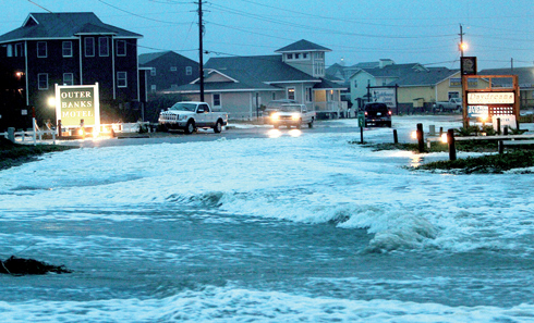
ATLANTIC CITY, N.J. (FinalCall.com) – Stripped of hurricane status but every bit as dangerous, the weather monster known as Sandy wheeled toward the New Jersey and Delaware coast Oct. 29 after washing away part of the Atlantic City boardwalk, putting the presidential campaign on hold and threatening to cripple Wall Street and the New York subway system with an epic surge of seawater.
Just before it was expected to blow ashore in the evening, the National Hurricane Center announced that it considered Sandy no longer a hurricane but a wintry hybrid known as a post-tropical storm.
The decision was technical and based on the storm’s shape and its mix of cold and warm temperatures–a distinction that meant more to meteorologists than the 50 million people still in peril. The storm’s top sustained winds weakened only slightly, to 85 mph from 90.
As it closed it, Sandy knocked out electricity to more than 1.5 million people and figured to upend life for tens of millions more. It smacked the boarded-up big cities of the Northeast corridor, from Washington and Baltimore to Philadelphia, New York and Boston, with stinging rain and gusts of more than 85 mph.
It was expected to come ashore in southern New Jersey or Delaware, converging with two cold weather systems to form a fearsome superstorm of snow, rain and wind. Forecasters warned of 20-foot waves bashing into the Chicago lakefront and up to three feet of snow in West Virginia.
Airlines canceled more than 12,000 flights, disrupting the plans of travelers all over the world, and storm damage was projected at $10 billion to $20 billion, meaning it could prove to be one of the costliest natural disasters in U.S. history.
Sandy, which killed 69 people in the Caribbean before making its way up the Atlantic, began to hook left at midday and was about 40 miles south of Atlantic City by evening, moving west-northwest at almost 30 mph–faster than forecasters expected.
The storm’s projected path would put New York City and Long Island along its dangerous northeastern wall, facing perhaps 11 feet of water.
“We are looking at the highest storm surges ever recorded” in the Northeast, said Jeff Masters, meteorology director for Weather Underground, a private forecasting service. “The energy of the storm surge is off the charts, basically.”
A construction crane atop a luxury high-rise in New York City collapsed in the wind and dangled precariously 74 floors above the street. Forecasters said the wind at the top of the building may have been close to 95 mph.
Off North Carolina, a replica of the 18th-century sailing ship HMS Bounty that was built for the 1962 Marlon Brando movie “Mutiny on the Bounty” went down in the storm, and 14 crew members were rescued by helicopter from rubber lifeboats bobbing in 18-foot seas. Another crew member was found hours later but was unresponsive. The captain was missing.
At least half a million people had been ordered to evacuate, including 375,000 from low-lying parts of New York City, and by the afternoon authorities were warning that it could be too late for people who had not left already.
Those who stayed behind had few ways to get out. New York’s subways, which serve five million people a day, were shut down. The Holland Tunnel connecting New York to New Jersey was closed, as was a tunnel between Brooklyn and Manhattan, and the city planned to shut down the Brooklyn Bridge, the George Washington, the Verrazano-Narrows and several other spans because of high winds.
Stock and bond markets were closed Oct. 29 and 30, the first shutdown since the days after the Sept. 11 attacks in 2001 and the first two-day closing of the stock market because of weather since a blizzard in 1888.
‘Watch the weather’ (Editorial on America’s divine destruction and warnings from Minister Farrakhan)